


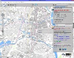
Flood Risk Maps (DARDNI)
Flood Maps (NI) is an interactive map-viewer that enables users to access the latest flood hazard information available from government for the whole of Northern Ireland.
The map highlights the areas throughout Northern Ireland that are prone to flooding and its potential adverse impacts.
The map is designed to -
- help us and others to plan and manage our work to reduce flood risk,
- encourage people living and working in areas prone to flooding to find out more and take appropriate action, and
- inform anyone applying for planning permission if flooding is likely to be an important consideration.
Supply format: Visual (no download options)
Data availability: See above.
Charge: No charge.
Sample available: N/A

 The Water Security Knowledge Exchange Portal supports the objectives of the