

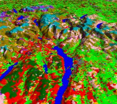
Land Cover Map (CEH)
Released in July 2011, Land Cover Map 2007 (LCM2007) is the latest land cover map to be produced by the Centre for Ecology & Hydrology. It covers the whole of the UK.
Over the last 20 years, CEH has produced three digital land cover maps: LCMGB 1990, LCM2000 and LCM2007. Each of these land cover maps has been produced as a number of different products with varying data formats and spatial resolutions. All of the products of the three land cover maps can be obtained from CEH under licence for academic, non-commercial and commercial use.
Data availability: Self download possible for 1km data via CEH Information Gateway after obtaining click-through licence. Quote request required for 25m raster data and vector data.
Charge: Available under licence and free of charge to academics and students for use on specific, named, non-commercial research projects. Administration and handling fees may apply.
Sample available: Download

 The Water Security Knowledge Exchange Portal supports the objectives of the