

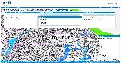
Flood Risk Maps (SEPA)
The Scottish Environment Protection Agency’s maps show where flooding may happen across Scotland so that individuals and groups can take appropriate action.
The available maps -
- help identify the most effective actions to manage flood risk and develop plans to tackle flooding,
- support emergency response to flooding by local authorities and emergency responders,
- support a more sustainable approach to managing flood risk by considering where natural flood management could be most effective, and
- enable better planning decisions to avoid unnecessary development in flood risk areas.
Supply format: Visual (no download options)
Data availability: See above.
Charge: No charge.
Sample available: N/A

 The Water Security Knowledge Exchange Portal supports the objectives of the