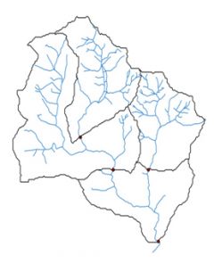
Catchment Boundaries (CEH)
Boundaries derived from CEH's IHDTM are available for all GB gauging stations within CEH’s National River Flow Archive. Boundaries can also be derived for almost any point on the UK river network. Hydrometric area boundaries are also available.
Supply format: Shape file
Data availability: Available immediately via the NRFA gauging station information pages. Boundaries are to gauging station sites but a gazeteer is provided for selection.
Be sure to check licensing details with licensor before use.
Charge: No charge for research use.
Sample available: Download

 The Water Security Knowledge Exchange Portal supports the objectives of the